In the far north of Australia, closer to Bali than Sydney, the sparsely populated, blisteringly hot “Top End” still feels like a frontier province. Despite its remoteness, Darwin, the biggest city in this tropical region, is remarkably cosmopolitan. Known as Australia’s gateway to Asia, it has a 135,000-strong population featuring over sixty nationalities. You can find authentic Indonesian, Malaysian, Thai, Chinese, Japanese, Vietnamese, Indian, Sri Lankan and Bangladeshi food here, plus countless fusion options.
Sunset at Mindil,Beach (c) Stephen Michael Barnett
The best place to sample this diversity is the twice-weekly Mindil Beach Sunset Market, 3km northeast of the city centre and home to almost 200 stalls. On Thursday and Sunday evenings during the “dry season” (end of April-October), it seems as if most of the city is here. The market is a hive of didgeridoo players, yoga demonstrations, tarot card readers, masseurs, and vendors selling everything from goat’s milk soap to crocodile-skin handbags.
Although you can find stalls offering souvlaki, roast lamb shanksand freshly-shucked oysters, Asian food dominates. Highlights include: Borneo Intersection, which serves Indonesian-Malaysian dishes like jackfruit curry and chilli tempeh (similar to tofu); Gourmet Sushi, whose rolls feature ingredients such as local fish barramundi, kangaroo and crocodile; and Bangladesh Curry Kitchen, which produces a fine okra-and-tomato curry.
First-time visitors, however, should head to the Darwin Laksa Co. A hot, spicy, coconut-rich soup served throughout Southeast Asia, laksa has become a fixture on menus across Darwin in recent years. For $10 (around £6) you get a steaming bowl of potent yellow-orange broth packed with noodles, sliced chicken, pork, beef or prawns, and a spongy cube of tofu. After customising the laksa with help-yourself sprinkles – ground peanuts, crispy onions, chopped coriander and chilli sauce – the only thing left to do is to join the locals on the beach for the sunset.
This is a longer version of an article that was first published here.
Tucked away amongst the green slopes of Costa Rica’s Central Valley, a sustainable tourism pioneer produces some of the country’s best coffee. I dropped in for a tasting – aka a “cupping”.
“Citrus? Wood?” I slurped another gulp of coffee and thought hard. “Chocolate, perhaps?” Ulises, who was patiently taking me through a cupping session on the verandah of Finca Rosa Blanca, just smiled. Ten minutes earlier, at the start of the tasting, I was struggling to pick out any specific flavours. The coffee, made by the traditional Costa Rican chorreador drip method, just tasted delicious. But gradually, thanks to Ulises’ guidance, my palate developed, and I began to distinguish different flavours, sensing peanuts, floral scents, even leather. Or at least I think I did: Ulises may just have been too polite to correct me.
Coffee beans drying in the sun (c) Shafik Meghji
Earlier in the day he had taken me on a tour of the coffee estate attached to Finca Rosa Blanca, one of Costa Rica finest – and most environmentally-friendly – hotels. It is scenically perched on a lush hill just outside the city of Heredia in the volcano-studded Valle Central (Central Valley), the heart of coffee country. Introduced here in the early nineteenth century, the crop flourished in the mineral-rich soil and quickly became a mainstay of the Costa Rican economy. Today the countryside is blanketed with a patchwork of fields, plantations, terraces and estates.
Several of the Valle Central’s coffee producers – including Costa Rica’s biggest exporter, Cafe Britt– offer guided tours, but Finca Rosa Blanca’s is perhaps the best. At just 30 acres, its organic estate is small by local standards, but stands out for its sustainable, low-impact approach, which produces excellent Rainforest Alliance-certified coffee.
Conventional coffee plantations, explained Ulises, often cause significant environmental damage, primarily through deforestation and soil erosion. By contrast, Finca Rosa Blanca’s estate is based around the idea of a balanced ecosystem. Some 5,000 native trees – including bananas and palms – shade the seemingly randomly scattered coffee bushes, which don’t like direct sunlight. The trees also provide nitrogen to enrich the soil and a habitat for birds, who in turn eat insects, which means that pesticides are not needed to protect the coffee bushes.
Over a hundred different bird species have been spotted on the estate, Ulises said, pointing out hummingbirds, flycatchers and squawking brown jays as we walked. The ecosystem, however, is also a home for some less welcome species, he added: the previous day a beautiful – but deadly – coral snake had been spotted in the undergrowth. I walked around very carefully for the rest of the tour.
Ulises showed me how the coffee bushes – which are arabica, the only species it is legal to plant in Costa Rica – are fertilised in part with compost made from the hotel restaurant’s organic waste. Between October and February the red berries are harvested by hand and their seeds – the coffee beans – dried in the sun, before being milled, pulped and finally roasted. The estate is over 4000ft above sea level, and the altitude hardens the beans, allowing them to be roasted for longer, producing a more aromatic, complex flavour. In total, the journey from bush to cup takes six to eight months, and the result is a smooth, mellow coffee that doesn’t need milk, let alone sugar.
After the cupping I had dinner with Finca Rosa Blanca’s American owners, Glenn and Teri Jampol. Since moving to Costa Rica 30 years ago, the couple, have pioneered environmentally-friendly travel, and Finca Rosa Blanca has the country’s highest sustainable tourism rating. When the coffee estate opposite came up for sale a few years after the hotel opened, it was a natural addition. The hotel makes full use of its produce: the in-house spa has a range of coffee-based treatments, while the restaurant menu features dishes like chicken in a coffee-and-tamarind sauce.
But it’s hard to beat a simple cup made from freshly roasted beans, especially when enjoyed on the terrace, with views across the Valle Central to the twinkling lights of the capital, San José, in the distance.
Finca Rosa Blanca provided the author with accommodation and the coffee tour. This article was first published here.
As improbable as it seems now, the summer of 2008 was a moment of optimism for Syria’s tourist industry. Tensions with the west had eased, travel agencies were returning, and positive articles appeared in the international press. Tourist numbers were rising too, particularly in Aleppo, one of the oldest continually inhabited cities on Earth.
Dating back to around 6,000 BC, the city has long been a meeting point between the Mediterranean and Mesopotamia, with enduring Ottoman, Armenian, Greek, French and Jewish influences. On a walk through the meandering streets, lemon trees scenting the air, I passed mosques, churches, even a synagogue. Mentioned in Macbeth and Othello, the city’s grand old buildings had been restored, townhouses had been turned into hotels, and rooftop restaurants offered views of the thirteenth-century citadel.
Aleppo’s focal point was the world’s largest covered market, the cacophonous, labyrinthine Souq al-Madina. There were precarious towers of dates, overflowing sacks of coffee beans, bloody carcasses of goats, cows and camels, pungent spices, platters of pistachios, fresh white cheese wrapped in cloth, cases of jewellery, textiles, silk and dyes, and greasy olive oil soaps.
Craftsmen rhythmically hammered out copper plates. Whirling circular saws were used to fashion wooden furnishings. Delivery boys trundled across the cobblestones on heavily-laden bikes, motorized carts and weary donkeys. Over tulip-shaped glasses of fragment tea, I swapped stories with a carpet-seller whose family had owned a shop here for centuries.
That Aleppo no longer exists. Travellers often like to delude themselves that the places they visit somehow remain preserved after their departure; Syria, brutally, allows no such illusions.
The summer of 2008 felt like a beginning, but was actually the end.
Never mind the Kumbh Mela, tourists could soon be flocking to Nashik not for its holy riverside, but for vineyards like Sula.
On the banks of the Godavari river, 170km north-east of Mumbai, Nashik is one of India’s holiest places. Every 12 years it hosts millions of predominantly teetotal Hindu pilgrims for the Kumbh Mela, the largest religious gathering on Earth. But this central Indian city now has another, rather unlikely, claim to fame. Surrounded by 37 vineyards, Nashik is the capital of India’s rapidly expanding wine industry.
Nashik’s Ram Kund (c) Arlan Zwegers
Domestic sales of Indian wine rose almost 20% in 2015, and a record 18 million litres are expected to be produced this year, and the quality is improving too: wines aimed at the Indian market are generally too sweet for international palates, but drier export varieties have won awards and a place on supermarket shelves (including in Marks & Spencer). Although there are vineyards scattered across India, Nashik district is at the heart of the industry, accounting for 80% of output, thanks to a favourable climate, fertile soils and a long grape-growing history.
Lucia didn’t look like a witch: early 20s, puppy fat, bored expression, tiny bowler hat. As I walked into her shop, ducking under a clutch of shrivelled llama foetuses dangling from the ceiling, her cell phone rang to the tune Shakira’s “Hips Don’t Lie”. She studiously ignored me.
The shelves of her shop, in La Paz’s Witches’ Market, were stacked with a bizarre collection of goods: aphrodisiacs with names like “Come to me, come to me” and “Love Honey”; perfumes promising to improve your mood or attract a partner; potions for everything from upset stomachs to hair loss.
There were rows of incense, soapstone figurines, penis-shaped candles, clumps of feathers, stone llamas, and wads of miniature dollar bills. Small bags contained seeds, herbal teas, coca leaves, vitamins, and “extracts” of snail and shark. Baskets held dead and dried armadillos, birds, turtles, starfish and frogs.
The Spanish brought Catholicism to Bolivia, but it never completely supplanted the indigenous religious beliefs, which continue to find their expression in rituals requiring an exotic array of ingredients.
Drawn, eventually, from her phone call, Lucia began to talk: “People come to me to prepare [“white tables”], small packages, to burn on the last Friday of each month, and more regularly in August, the month of Pachamama, for good luck. Sometimes they come for , black magic, to cause harm to others.” She pointed at the little figurines: “Each one represents something different. The owls mean studying; the entwined couple, love; the puma, protection; the condor, travel.”
And then, because witches need to make a living too: “You need to buy some condors now, to bring good luck on your journey.”
Four months after two devastating earthquakes struck the country, Nepal is slowly getting back on its feet. As the peak tourist season gets underway, travellers can help the country recover by booking a holiday.
Why should you go?
Tourism is a vital part of the Nepali economy, directly supporting almost 500,000 jobs, and indirectly supporting many more. “Tourism is the backbone of Nepal’s economy, the major employer” says Ramesh Chaudhary, a leading guide. “Nepal’s economic sustainability heavily depends on tourism. Tourists can help alleviate poverty by traveling in various parts of Nepal. The number of tourists decreased drastically aftermath of the earthquake, but they have started coming again.”
Is it safe?
In July the UK Foreign and Commonwealth Office and the US State Department both softened their travel warnings for citizens visiting most parts of Nepal. Although travel companies cancelled trips in the aftermath of the earthquakes, many are now running tours for the post-monsoon peak season, which runs from late September to late November.
“Following the earthquake we were overwhelmed by the response from our customers inquiring after the wellbeing of the local guides and partners we work with in Nepal,” says Lloyd Kane, senior manager at Rickshaw Travel, which is running a range of trips this year. “We have been speaking to our partners in Nepal every day since the incident and recently sent a team of senior staff members out to Kathmandu and the surrounding area to offer their support and find out what it’s like to travel in the country. They reported that life in Kathmandu is slowly getting back on track, hotels are open and ready to welcome guests and the country is as beautiful and hospitable as ever.”
Where can you go?
The earthquakes affected 14 of the country’s 75 districts. Although the devastation is extensive in these 14 central districts – they will take many years to recover, and travellers should avoid them for now – the remaining 61 survived relatively or completely unscathed and are safe to visit. For example, the tranquil lakeside city of Pokhara, the national parks of Chitwan and Bardia – home to rhinos, elephants, tigers and a wealth of other wildlife – and Lumbini, birthplace of the Buddha, all escaped major damage.
What about Kathmandu?
The capital – and the surrounding valley, the country’s cultural heartland – was badly affected by the earthquakes, but is now getting back to normal. In July UNESCO decided not to put seven Kathmandu Valley World Heritage Sites on its “danger list”, and they are now open to the public again. Some – including the mesmerising Buddhist stupa at Boudha and Pashupatinath, Nepal’s holiest Hindu pilgrimage site – were largely untouched. Others, such as Kathmandu’s Durbar Square and the Swayambhu Temple, suffered significant damage, but restoration work is underway.
“Generations of skilled artisans have built and rebuilt these sites over the centuries,” says Mads Mathiasen, who runs Nepal-based tour operator Himalayan Trails. “The heritage is not only in the bricks and mortar we see today. It is also in the spirit of the place and the connection of the people who live here, worship here and maintain these areas, including rebuilding the physical structures after earthquakes, fires or other types of damage which inevitably occur over time.”
More than 90 per cent of Kathmandu’s hotels and guesthouses, particularly those in the tourist hub of Thamel, have reopened. Look for one with a green sticker, which indicates that government engineers have assessed it as safe: for a list of hotels with the green sticker, visit this site. Most restaurants and travel agencies are also open for business, there is electricity (though the regular pre-earthquakes power cuts continue) and internet access, and ATMS are functioning as normal.
How do I get there and around?
Kathmandu’s international airport remained open throughout the earthquakes, and continues to be served by a wide range of airlines. Most of the regional airports and the major roads are also open, and outside of the worst-affected areas, it is straightforward to get around.
Can you go trekking?
Yes. Miyamoto International, a major engineering firm, has carried out assessments of the major trekking areas. It judged that both the Everest and Annapurna regions will be safe to trek in after the monsoon. The Trekking Agencies’ Association of Nepal is overseeing assessments of other trails, and says most of the other popular trekking regions – excluding Langtang, Rolwaling and Manaslu – are also safe.
What about insurance?
It can be a tricky getting insurance for trips to Nepal, though the situation is likely to improve over the coming weeks and months: travel agencies can provide the latest advice.
Where can you find out more?
Nepal’s tourist industry runs a useful Facebook group. The About Nepal Now website, a collaboration between travel experts and the Nepal Tourism Board, will be similarly helpful when fully up and running.
For many years Chiapas and Tabasco were famous for revolutionaries, chilli sauce, and little else. But these neighbouring Mexican states are increasingly appearing on tourist itineraries, drawing in travellers with their magnificent ruins and colonial cities, unique indigenous cultures, and lip-tingling cuisine.
San Juan Chamula chruch (c) Journey Latin America
Chiapas
Stretched along the Guatemalan border in Mexico’s far south, Chiapas is an incredibly culturally and biologically diverse region. Its landscapes feature mountains, valleys, forests, lakes, beaches, and coffee plantations, while some twenty-five per cent of its population belong to indigenous groups.
In the mid-1990s Chiapas became synonymous with the Zapatistas, a left-wing guerrilla group that launched a brief uprising against the government. Today, however, the group’s struggle is largely intellectual rather than military, and won’t impact negatively on your visit to one of Mexico’s most attractive states.
Colonial cities and indigenous beliefs
A glorious colonial city, San Cristóbal de las Casas is the tourist hub of Chiapas, and a tough place to drag yourself away from. Home to a cosmopolitan community – there are sizeable expat and indigenous populations – the city is a mix of attractive townhouses, Baroque- and Moorish-inspired churches, bustling markets (where you can buy anything from silver jewellery to plates of fried ants), hundreds of restaurants, cafes and bars with tables spilling out onto the streets, and a refreshingly cool climate.
San Cristóbal is also the jumping off point for day trips to the indigenous villages of San Juan Chamula and San Lorenzo de Zincantán. The Tzotzil Maya community here have fused their traditional beliefs with Catholicism to create a unique religion that features Christian saints, animal sacrifices, and medicine men, but no priests, masses or church marriages.
For a change of pace, head southeast of San Cristóbal towards the Guatemalan border and Parque Nacional Lagos de Montebello, a beautiful reserve with more than fifty lakes surrounded by pristine forests. More reminiscent of Scotland or Maine than Mexico, the landscape, dotted with cabins and picnic spots, is ideal for hiking, swimming and horseriding.
Jungle ruins
Chiapas also has some breathtaking archeological sites. In a dramatic setting high on a hill, surrounded by insect-rich jungle and commanding views across the Yucatán plains, the ancient Mayan city of Palenque is the most popular attraction in the state. Flourishing between 300 and 900 BC, the site is dominated by an eight-stepped, 25m-high pyramid, the Templo de las Inscripciones, and El Palacio, an impressive complex of residential and administrative buildings. If you have a head for heights you can clamber up the latter for some panoramic vistas.
Further south, drawing far fewer tourists, the ruins of Bonampak contain the finest collection of Mayan murals in Mexico. The highlight of the site, which lies in a small natural park on the fringes of the Montes Azules Biosphere Reserve, is the Edificio de las Pinturas. Inside are three chambers with evocative, colourful images of noblemen dressed in jaguar-skin robes and quetzal-plume headdresses, tortured prisoners pleading for mercy, and even a severed head.
Tabasco
Winding along the Gulf of Mexico, the smaller state of Tabasco is humid, largely flat, and criss-crossed by rivers and swamps. Bordering the Yucatán Peninsula – the most touristy part of Mexico – the state receives few travellers but has plenty of things to offer. Tabasco sauce, however, is not one of them: although named after the state, the peppers don’t grow there and the condiment is actually a US product made from peppers harvested in Louisiana.
Giant heads in a “beautiful city”
As Graham Greene pointed out when he travelled through Tabasco in the 1930s, Villahermosa doesn’t necessarily live up to the name “beautiful city”. But while Tabasco’s capital may not be the most aesthetically pleasing place, it has some fascinating attractions that you’re likely to have all to yourself.
The highlight is Parque La Venta, which displays relics from the Olmec site of the same name amid a jungle teeming with birds and butterflies and echoing with jaguar growls (which emanate from the adjacent wildlife park). Along with the sculptures, altars and tombs are a series of giant basalt heads for which the Olmecs – the mother culture of Mesoamerica – are famous.
Villahermosa is also the best spot to sample Tabasqueño cuisine, which is rich in tropical fruits and freshwater fish. Keep an eye out for the local super-sweet pineapples, the tasty pejelagarto fish (which is generally barbecued and served with a fiery sauce), and horchata de coco, a rice-milk drink spiked with coconut.
Beyond Villahermosa
There are some easy but worthwhile day trips from Tabasco’s capital. Some 100km southwest are the rugged Sierra Huimanguillo mountains, home to canyons, waterfalls and the petroglyphs of Malpasito. Meanwhile 58km north of Villahermosa are the Mayan ruins of Comalcalco, whose temple, acropolis and palaces are distinctively built from kiln-fired bricks.
Shafik travelled with Journey Latin America who offer a 15-day trip to Mexico City, Oaxaca, San Cristobal de las Casas, Palenque, Villahermosa, Campeche, Mérida, Chichén Itzá and the Riviera Maya for £3,340 per person (including B&B accommodation, some meals, excursions, transfers and flights).
A version of this article was first published here.
As I ducked through a narrow gap in the jagged limestone the first sense was of relief, as a quenching shade replaced the skin-blistering, 40-degree, pre-rainy season heat outside. My flip flops echoed around the cave as I descended the narrow flight of steps that had been cut into the rocks into what felt like a scene from an Indiana Jones film.
A shaft of sunlight pierced through a circular hole in the roof, illuminating the gloom and refracting off the vast, crystal-clear pool below. Bats fluttered above, vines crisscrossed the ceiling, and stalactites stretched down, like frozen drops of pitch. As I slipped into the bracingly cool, crystal-clear water small black catfish nibbled at my toes. For a glorious 15 minutes or so I had Cenote X’Keken, just outside the city of Valladolid, to myself.
Afterwards I braved the midday sun again to explore the nearby Cenote Samula, which is perhaps even more spectacular than its neighbour. The dome of the cave was punctuated by a sizeable hole, through which the gnarled roots of an ancient tree dangled, tantalisingly out of reach of the frigid, turquoise water below. Despite the high temperatures outside, and the fact that it was a Sunday, there was only one other person there.
The region’s network of cenotes – limestone sinkholes, generally filled with fresh water – was vital for the Mayan civilization that dominated the Yucatán Peninsula before the arrival of the Spanish conquistadors in the 1500s. And it is easy to see why they were considered sacred gateways to the Mayan underworld, known as Xibalba (“the place of fear”).
At the Cenote Sagrado, a murky green pool at the famous ruins at Chichén Itzá, for example, the Mayans threw statues, pottery, incense, textiles, jade, gold, and human sacrifices into the water as offerings to the gods of the underworld. The few human sacrifices who survived the ordeal, incidentally, were considered to have spoken with the gods, and have developed prophetic powers. (The conquistadors, rabid for gold, ransacked Chichén Itzá for the precious metal, largely in vain, unaware that the riches they sought were so close at hand.)
Many of the other cenotes in the region hold even older treasures: in recent years divers have discovered human skeletons that date back nearly 14,000 years, and even the remains of a mastodon (a prehistoric pachyderm).
Yet the cenotes, which collectively form vast largest cave systems, have an even greater significance, being linked to one of the most significant events in the history of the earth. Some 66 million years ago the Chicxulub asteroid struck the Yucatán, an event that is considered to have contributed to the extinction of the dinosaurs. The strike also caused large sections of the region’s limestone bedrock to collapse, in turn forming thousands of cenotes.
The Mayans later founded their villages and towns around these flooded subterranean chambers, which, given the lack of lakes and rivers in the region, were vital sources of fresh water. Today many of these cenotes – known collectively as the “Ring of Cenotes” – have been turned into major tourist attractions, for example, at the Xel-Há theme park near Tulum. But others are far less developed, with little in the way of facilities and few visitors.
For experienced divers with a sense of adventure – and no sense of claustrophobia – Dos Ojos (“Two Eyes”) is one of many that are worth exploring further. The water is incredibly clear here and this high visibility means photographers can get some incredible shots. And even if you don’t fancy strapping on a scuba tank, you can still have an evocative experience with a mask and a snorkel.
I finished my trip at Cenote Yokdzonot, located in a dusty, sleepy village a short drive away from Chichén Itzá. Looked after by a local cooperative, which provides a stack of lifejackets, a couple of rustic shacks to change in, and a set of rickety wooden steps, the cenote is rarely visited by foreign tourists.
Open to the elements, the deep, circular sinkhole is shaded by tall trees. After rousing the slumbering ticket-seller to pay the small entry fee, I dived into the aquamarine, seemingly bottomless water. A couple of local children splashed about, thick tangle vines spiralled gently in the breeze and tiny birds, moving too fast for the human eye to focus on, swirled above. It was a perfectly relaxing scene – at least until my mind turned to the human sacrifices that might lie at the bottom.
The Cambrian Mountains should be a tourist hotspot. Midway between the Brecon Beacons and Snowdonia, and within striking distance of Aberystwyth, the region is blessed with spectacular, remarkably unspoilt scenery, perfect for hiking, wild camping and stargazing. Yet the region – dubbed the “Green Desert of Wales” in reference to its sparseness of population, rather than its terrain – remains firmly off the beaten track.
Aled, my guide from Expeditions Wales, meets me off the train at Aberystwyth, after a picturesque three-hour ride from Birmingham New Street. We stop off at his HQ, just beyond Devil’s Bridge Falls, to pack up our camping gear, a pair of red kites circle above us while we do so. A twenty-minute drive takes us to the end of the road, where a small herd of stately Highland Longhorn cattle languidly enjoy the views over the glistening Nant y Moch reservoir.
The aim for the day is to ascend the 752-metre Pen Pumlumon Fawr, the highest point in the Cambrian Mountains region. In the afternoon sun we squelch steeply uphill, passing clumps of sphagnum moss, patches of frogspawn, and large chunks of quartz that appear to have dropped from the sky. Buzzards appear overheard. It is perfectly quiet and still.
On the summit we hunker down behind a cairn. Aled points south towards the Brecon Beacons, north to the peak of Cadair Idris at the southern edge of Snowdonia National Park, and across to the sources of the Wye and Severn rivers. On a really clear day, he tells me, you can see across to Ireland.
Below us is an undulating landscape of gurgling streams and waterfalls, expansive lakes and reservoirs, green-tinged peaks, and lush valleys and forests. The only obvious signs of human impact – beyond the man-made reservoirs, which meld seamlessly into the natural landscape – are a field of distant wind turbines and some wonderfully isolated, and now abandoned, stone farm buildings. We see just one other person, a hardy runner.
Refreshed by a well-deserved cup of coffee we hike over and up our second mountain of the day, the slightly lower Pen Pumlumon Arwystli. En route we tramp through thick, soft grass, occasionally plunging knee-deep into a hole; hiking through this landscape burns some 500-600 calories an hour, says Aled. A glorious sunset shortly arrives, accompanied by a great example of “dragon’s breath”, as a cloud of wispy mist swirls up the mountainside below us, briefly turning the peak we’re standing on into an island.
The Cambrian Mountains are wonderfully unaffected by artificial light, making them ideal for stargazing: one section, the Elan Valley estate, near Rhayader, is currently applying for international dark sky status. Sadly, after setting up our tents in an idyllic valley, beside a bracingly cold stream, the clouds descend.
So no stargazing for me – though I do have the perfect excuse for a return trip to one of the UK’s most beautiful landscapes.
Expeditions Walesoffers guided walks, wild camping, survival skills, and map-reading expeditions in the Cambrian Mountains. Shafik travelled with Arriva Trains Wales, which has regular services between Aberystwyth and Birmingham New Street.
A version of this article was first published here.
For most travellers the hills to the west of Kathmandu mean only one thing: the buzzing resort of Pokhara, which draws many thousands of tourists every year. But the region is actually home to a wide range of little-visited attractions.
Begnas Tal and Rupa Tal
Phewa Lake helped to put Pokhara on the tourist map, but it is now crowded by an ever-growing number of hotels, restaurants, bars and shops. Just 15km to the east, however, are two equally beautiful, under-visited lakes, with little of the over-development that threatens to overwhelm Pokhara.
According to local legend, Begnas Tal and Rupa Tal are husband and wife, and if you throw something into one of them, it will eventually appear in the other. The former, the bigger of the two, is framed by impossibly steep, terraced hills, while the latter is hidden away in a lush valley just to the south. Both of the lakes have the majestic snow-capped, tent-shaped peak of Annapurna II in the background, and white egrets and ospreys flying overhead – and occasionally swooping down to snatch up a fish.
Kahun Daada
Flocks of tourists hike up the mini peak of Sarangkot, just west of Pokhara, to take in the superb views, yet similarly impressive vistas can be enjoyed in virtual isolation on the eastern edge of the city at the top of Kahun Daada hill. The route up to this viewpoint also takes you through some fascinating cultural sites.
On the outskirts of the city an exacting flight of over 200 steps takes you to the intricate Manang monastery, home to around 70 Buddhist monks and site of some superb views. A ten-minute walk from the monastery, up another few hundred steps, is the Hindu Bardakali temple, which is surrounded by flowering bougainvillea and is a popular – and suitably dramatic – spot for weddings.
From here, you pass through traditional villages before reaching several uncrowded trails to the 1442m summit of Kahun Daada. Here there are stunning views of the Annapurna range, notably the 6667m-high Machhapuchhare Mountain, popularly known as the “Fish Head” for its distinctive shape.
Manakamama
Nepal’s most famous wish-granting temple, Manakamama Devi attracts vast numbers of domestic and Indian pilgrims, but very few other foreign tourists. It is accessed by Nepal’s only cable car (www.chitawoncoe.com.np), which whisks you swiftly up 2.8km through the clouds to the hilltop temple. You may find yourself sharing a gondola with a tethered goat, pigeon or chicken – animal sacrifices are common here. After disembarking, a trail of guesthouses, tea shops, and clusters of stalls selling devotional items – including coconuts, flower garlands and gold-trimmed shawls – leads up to a small square, which bustles with energy.
There, in the shade of a giant champ tree (a type of magnolia), the two-tiered temple is surrounded by a gaggle of pilgrims, priests and sadhus (Hindu holy men, many of whom opt to walk up the hill rather use the cable car), who light candles, ring bells, chant hymns, ask the goddess Bhagwati to grant their wishes and snap photos. Beyond the temple there are superlative vistas down to the confluence of the Trisuli and Marsyangdi rivers, and across to the Himalayas.
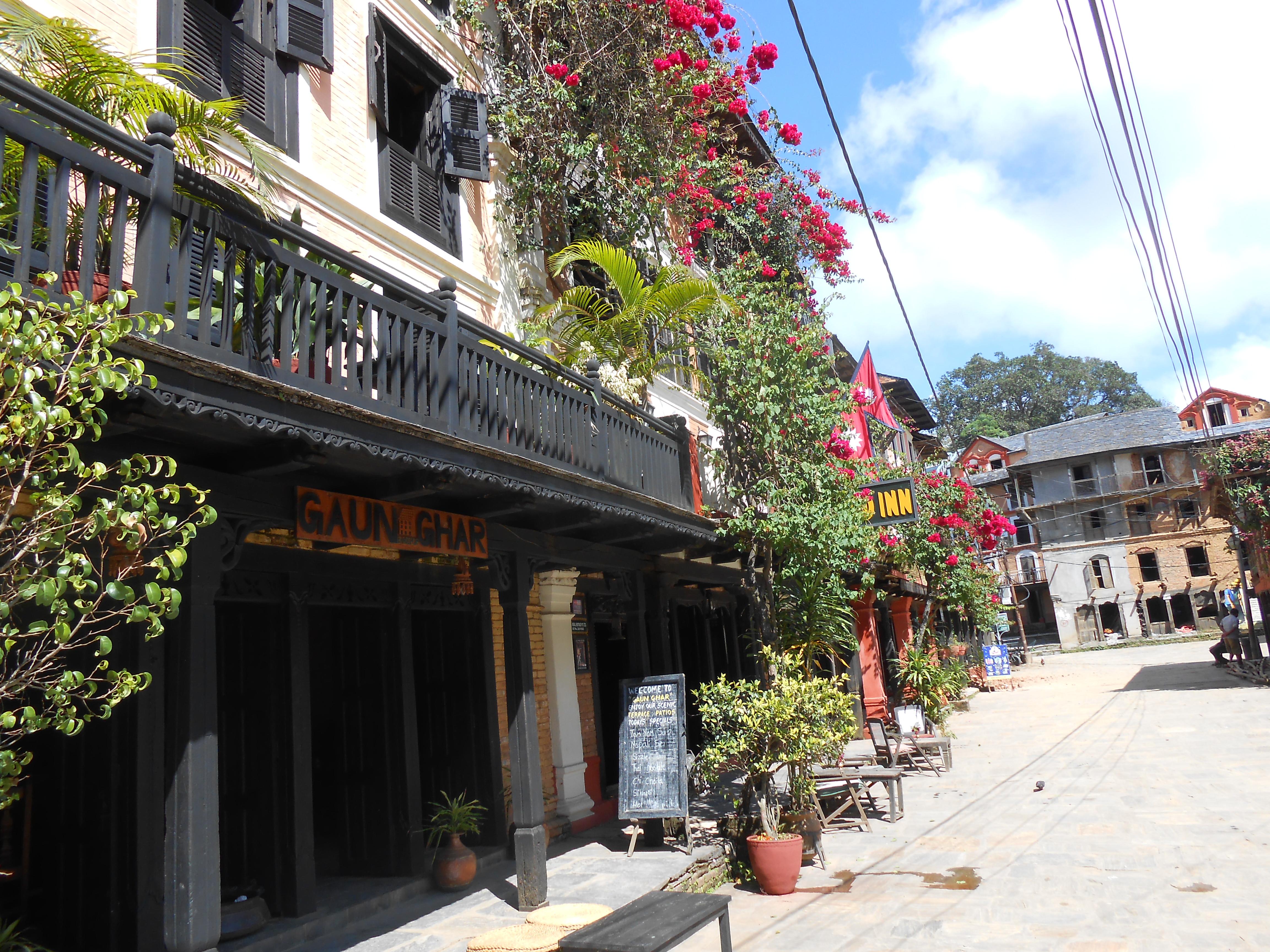
Bandipur
It’s hard to imagine a more picture-perfect town than Bandipur. Located at the top of a series of limestone cliffs, and linked to the world below by a serpentine, winding road, Bandipur was an important trading post in the 1800s.
But road construction elsewhere in Nepal meant that it slowly fell from prominence, and today it feels frozen in time. The sleepy, vehicle-free bazaar area is filled with wonderfully preserved, nineteenth-century mansions, with shuttered windows, intricately carved wooden doors, and facades covered with creeping vines and flowers. Several of these homes have now been turned into atmospheric boutique hotels – notably the charming Old Inn – and the town is a wonderful place to relax and watch the world go slowly by. A short walk from the bazaar is the tudikhel (parade ground), which protrudes out of the ridge, with sheer drops on two sides, a line of fig trees on another and the Himalayas straight head.
Gorkha
The ancestral home of Nepal’s former royal family, and a town steeped in history, Gorkha should be an essential stop on any itinerary of Nepal, but it receives barely a trickle of foreign travellers. Its highlight is undoubtedly the magnificent eighteenth-century Gorkha Durbar, a stiff 40-minute climb up a flight of stone steps from the lower town, something that is best attempted in the morning before the heat rises.
The Durbar itself is a real feat of architecture and engineering: half palace, half temple, the brick-and-wood construction is perched precariously on a high, narrow ridge. It was from here that Prithvi Narayan Shah conquered the country’s valley kingdoms and unified the modern Nepal. The Durbar, which gazes out towards the Himalayan mountains of Ganesh Himal, the Annapurnas and Dhaulagiri, is a hive of activity during the Chait Dasain festival in late March or early April, when there are processions, ancient rites and animal sacrifices.
If you’ve got any energy left from your ascent to the Durbar, hike up for a further 30 minutes or so to the much smaller Upallokot (Upper Fort), which stands at some 1520m.
A version of this article was first published here.


 Dating back to around 6,000 BC, the city has long been a meeting point between the Mediterranean and Mesopotamia, with enduring Ottoman, Armenian, Greek, French and Jewish influences. On a walk through the meandering streets, lemon trees scenting the air, I passed mosques, churches, even a synagogue. Mentioned in Macbeth and Othello, the city’s grand old buildings had been restored, townhouses had been turned into hotels, and rooftop restaurants offered views of the thirteenth-century citadel.
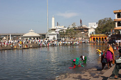
 The shelves of her shop, in La Paz’s Witches’ Market, were stacked with a bizarre collection of goods: aphrodisiacs with names like “Come to me, come to me” and “Love Honey”; perfumes promising to improve your mood or attract a partner; potions for everything from upset stomachs to hair loss.